


Space — Time Vertigo
Brett Milligan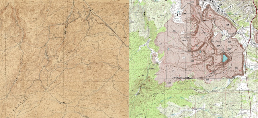
Surveying New Terrains
In 1897 the United States Geological Survey (USGS) began the task of surveying the entire nation. From 1897 to 1992 the survey produced over 55,000 7.5-minute topography maps, creating the only uniform map covering the entire extent of the lower continental 48 states in detail.[1] These surveys became the definitive source for remote sensing[2] the country’s lands and what was being inscribed upon them. In contrast to its strictly ‘geologic’ surveys, inventories of subsurface mineral deposits, USGS topographic maps gave equal consideration to surficial landscape features (landforms, rivers, and streams) as well as our cultural alteration of those forms and surfaces. Because the topographic surveys mapped the cultural terrain, they needed to be periodically updated to include how our use of the landscape was changing it.
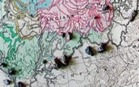
Figure 1 shows two USGS topographic maps depicting the same location and extent of Basin and Range territory in southwestern New Mexico. The first was surveyed around 1915 and the second around 1992. In the interval between them, the survey’s conventions for drawing the landscape remained largely the same. Differences in style are subtle in comparison to the massive physical changes in the terrain they depict. What in 1915 was a landscape of undulating hills, underground mine shafts and the sprawling town of Tyrone has vanished within the manufactured geography of an open-pit copper mine. In the process, over seven contiguous miles of the former Continental Divide was displaced from its former location.
Overlays of surveys such as these provide time-lapse snapshots of the arrival of the Anthropocene, or the era of the "human-influenced environment."[3] At this distant scale (1:24,000 in the original maps), we can see the anthro-geology of open-pit mining occurring at a pace exponentially faster than the relatively unchanged terrain surrounding it; an anthro-geology that comes with its own repertoire of landscapes and processes.
back to top ↑Engineered Geologies
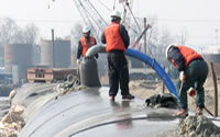
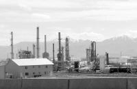
The amount of copper recoverable in the mining of porphyry deposits such as Tyrone’s is typically less than 0.8% percent of the total quantity of rock being mined. The economy of scale required to make these operations profitable is manifest in the monumental re-sculpting of the terrain it works with. As anthropogenic facsimile of a geologic eruption, unknown numbers of nitroglycerine explosives were detonated at the Tyrone Pit over 25 years (1967-1992) to blast apart the Precambrian to Quaternary aged formations. Once fractured, the rock was shoveled into a fleet of 50’ tall trucks, each capable of hauling 350 tons of material to one of two accelerated geologic processes. Higher grade ores were taken to the mine’s mill where they were pulverized into a sandy slurry for extraction of copper through floatation and smelting. Lower grade ores were heaped into stockpiles towering over 300 ft. tall around the pit at their angle of repose. The stockpiles were (and still are) irrigated with a percolating solution of sulfuric acid that leaches the copper deposits from the rock. This pregnant leachate is collected from ponds at the stockpiles’ bases to enter the Solution Extraction -- Electrowinning Process (SX-EW) which is able to transform liquid copper into solid, 99.9% pure sheets.[4]
At sites such as these, copper is amalgamated and then dispersed into a global urban network. As it settles into that network, it is re-deposited in subcutaneous locations, such as the internal wiring of buildings, appliances, computer hardware, and power tools. It is more than likely that there are former pieces of Tyrone’s geology now embedded in either your automobile, household or surrounding community, regardless of where you live.
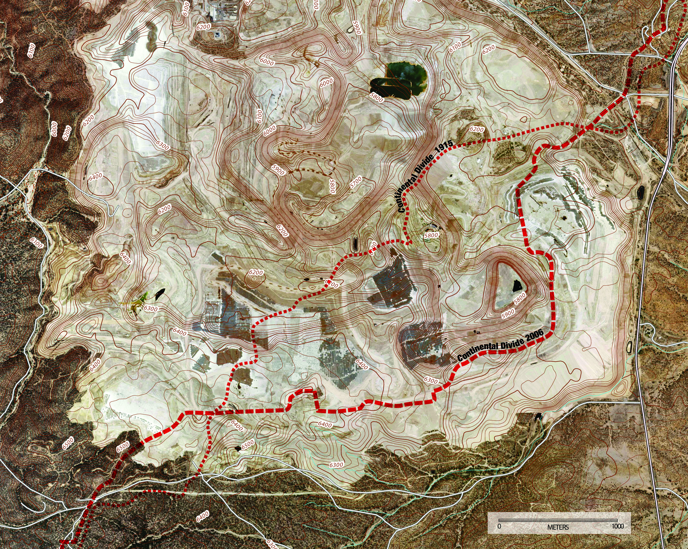
Image by author using overlays of USGS surveys
GIS data courtesy of USGS
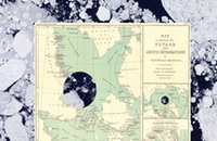
Incidentally Shifting the Continental Divide
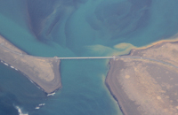
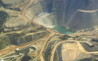
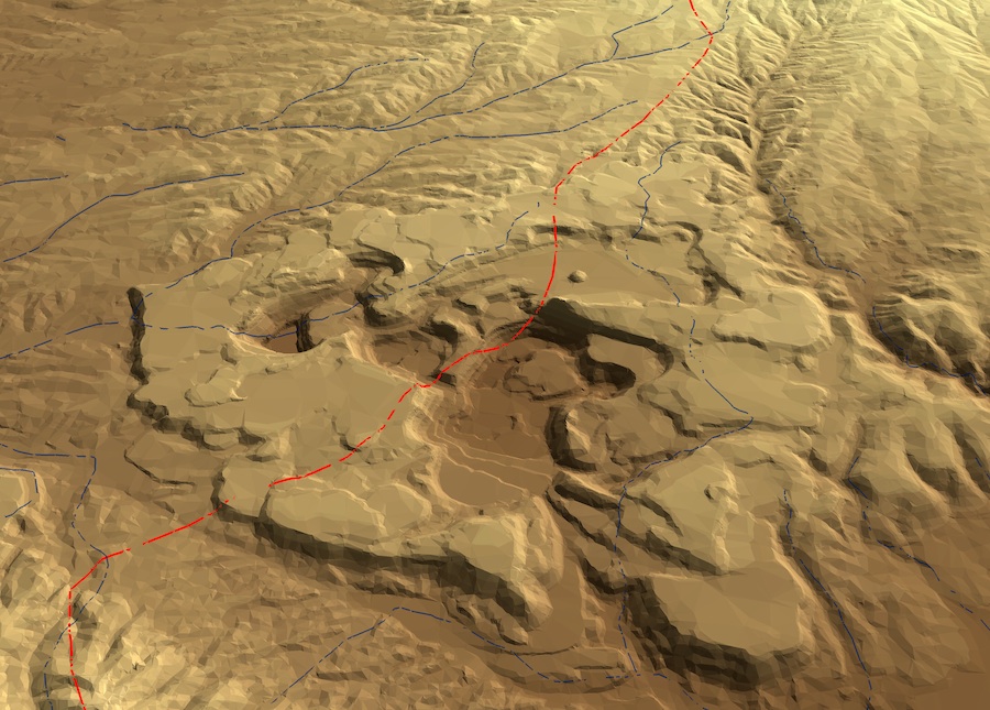
Within the expanse of the Tyrone mine, the exact location of the Continental Divide has become rather tenuous and mutable. If we trace where the former divide was surveyed to have been in 1915 and superimpose it onto a current aerial, it shows a hydrological line defying all rules of topographic sensibility as it diagonally waltzes up the sides of geometric mesas and whimsically meanders into the depths of an open-pit (Figure 2). If Tyrone’s manufactured topography is modeled in three dimensions with the former line of the continental divide draped upon it (Figure 3), its path reads like the soft, malleable indexes of space-time seen in Salvador Dali’s The Persistence of Memory (1931). Only the conceptual trace of the former Great Divide, the division between Pacific and Atlantic watersheds as seen and recorded a century ago, remains. The cultured geology that rapidly superseded what was there is persistent and irrevocable. If one were to try to push all the earth back into the open-pit at the same ambitious rate at which it was pulled out (a span of only 25 years), it would take an additional 125 years (and $1.5 billion) to replace the 4 to 5 billion tons of material removed from the hole.[5]
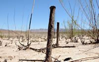
Tyrone’s geo-displacements provide a distinctive ‘landmark’ along the Continental Divide Trail; a marking of the land where human agency is predominantly expressed in the altered stratigraphy of the Earth’s crust (Figure 4). Yet the new path of the Continental Divide was not intentionally shaped. Rather its epic reshuffling is a mere by-product of industrial engineering. But more oddly, this shift of the Divide is essentially ignored in current field guides for the Continental Divide Trail. This segment of it is only mentioned as a required highway detour, which seems a missed opportunity to observe a seemingly incongruous and cognitively dissonant encounter along the “wild and remote” landscapes of this “backcountry trail.” For at this location, one encounters an entirely new watershed detonated into the topographic seam of the continent.
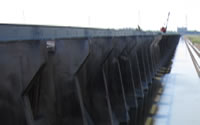
Before the Tyrone mine was here, precipitation falling on this landscape was shunted away by gravity either towards the Pacific or the Atlantic Ocean, depending upon which side of the Divide it fell on. The novel tectonics of mine operations inverted that hydrologic pattern, whereby water falling on or deliberately applied to the 5,000 acres of the open-pits and surrounding stockpiles is contained and recycled within a choreographed system of ponds, pipes and pumps. Additionally, the main pit is sufficiently deep to form a “hydraulic sink” that pulls all regional groundwater towards itself.[6] If this water was not routinely pumped out of the pit (which increases the sink effect) it would fill with a lake containing 2200 mg/l sulfate with a pH of approximately 3.5[7] (Figure 5). We know this from inadvertent "pit lake" experiments at the Berkeley open-pit mine in Butte, Montana. When the Berkeley mine closed in 1982, its dewatering pumps were also turned off. Since then the pit has continued to fill, forming the largest Superfund body of water in the United States.[8] These waters, corrosive and fatal to most life forms we know, are giving rise to entirely new microorganisms that are quickly adapting to life in the sumps of the Anthropocene.[9]
Parts of the Tyrone mine are currently being reclaimed. Tailing impoundments and stockpiles have been recontoured and covered with soil and vegetation for their approved post-mining land use as "wildlife habitat;" a herculean conversion of disparate land forms and uses performed so quickly that it makes the terrain seem like geologic stage sets.[10] However, the open-pit will remain as a monument of unreclaimability, and Freeport McMoRan will continue to pump, treat and contain water within the mine for at least another 100 years, if not in perpetuity to prevent the formation of spontaneous toxic lakes and streams[11]. The residual geology of mining has led to the design and management of a watershed with as much permanency as the path of the Continental Divide.
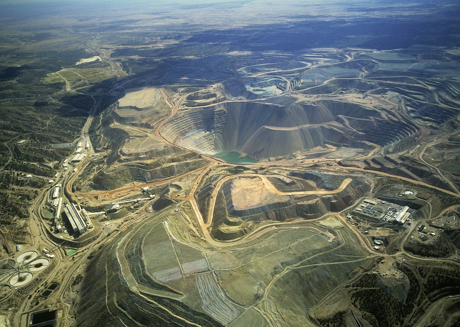
Image courtesy of aerial photographer Jim Wark
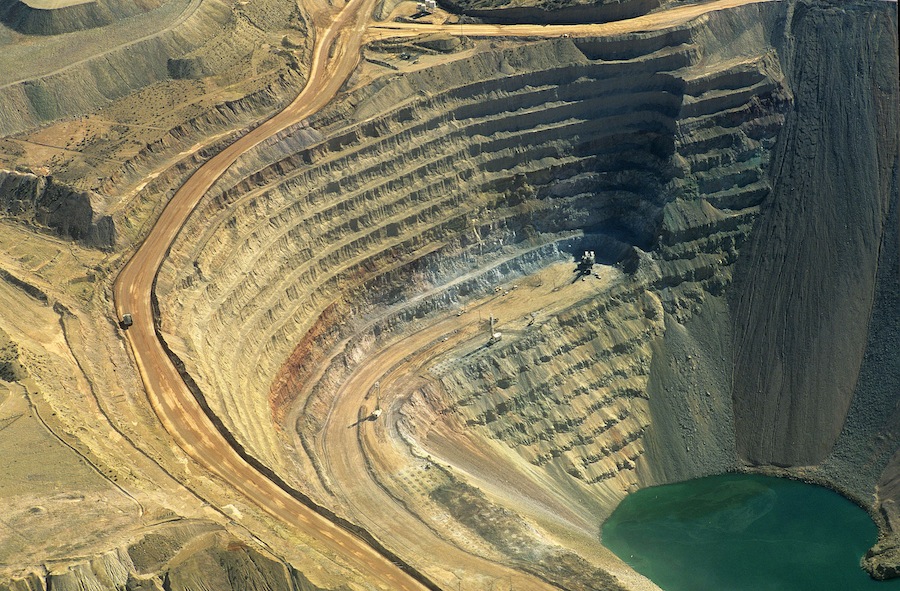
Image courtesy of aerial photographer Jim Wark
Acceleration and Displacement
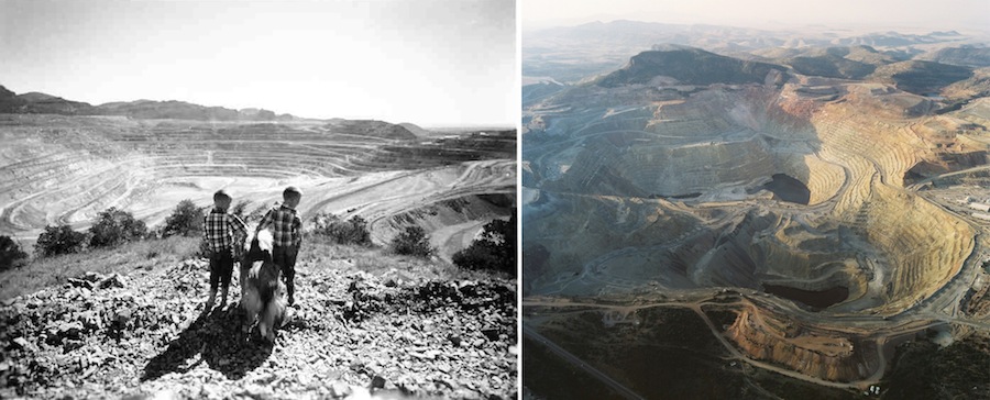
1961 image courtesy of New Mexico State University Library Special Collections
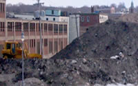
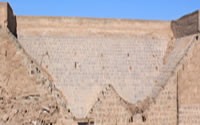
Aside from the remote sensing that maps and aerial photographs can provide, we are still left with what it is actually like to physically be with such anthropogenically accelerated geologies. If we were to travel just 20 miles northeast of Tyrone, we would encounter the Santa Rita Copper Mine. Without surrounding landmarks to tell us otherwise, we might actually feel that we were still at Tyrone, as the Santa Rita Mine is remarkably similar in its massive, constructed form. Santa Rita also had a company town (Santa Rita) that was erased by the same land use for which it was founded. Where that town once was, there is now a vacuous and dusty air space above a mile-and-half wide pit. One can stare out at that space from the rim of the pit at a marked overlook on highway 152.
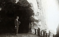
Harrison Schmitt, a geologist and Apollo 17 astronaut who walked on the moon, was born in the former Santa Rita Hospital. After completing his outer space mission, Schmitt joined with other Santa Ritans to re-inhabit the void of their birthplace by forming the Society of People Born in Space (SPBS) in the mid-1970s. The group was dedicated to celebrating their shared birth place identity and would get together annually to explore the gaps between the terrain they used to inhabit, and the non-entity it is now[12]. Given that the town of Santa Rita was fully dismantled by the early 1960’s, the number of those who retain physical, embodied memories of the town grows ever smaller.
Local historian Terry Humble is a member of the SPBS and worked for the Santa Rita Mine for over 30 years. One room of his home is entirely dedicated to historical documentation of both the mine and town of Santa Rita. While sitting in this room full of all sorts of material artifacts, Terry informs me that his house (currently in the town of Bayard) is a Santa Rita original that was relocated here more than fifty years ago[13]. He mentions this while I’m staring into an 8-foot black-and-white panoramic photograph of the still-intact town of Santa Rita, looking at a blackish dot that could have been his house. In the background of the photograph a spray of dust can be seen escaping from the expanding pit, obscuring the landscape behind it; dust that is difficult to locate amongst active fault lines between mind, earth and flesh. As Robert Smithson observed, it is at such indeterminate points where those fault lines intersect that friction worth noticing seems to arise.[14] The novel forms and displacements of the anthropocene occur not only in earthen piles and pits, but in the granular mental strata trying to find the angle of repose within its new terrains.
back to top ↑Notes
- The task set by the United States Geological Survey, as officially stated was, the "classification of the public lands, and examination of the geological structure, mineral resources, and products of the national domain": USGS, http://ncgmp.usgs.gov/ ncgmpgeomaps/geomaphistory/. ↑
- Remote Sensing is the act of obtaining information about an object or phenomena without actually making physical contact with it. More specific to geography and the study of landscapes, remote sensing is "the process of collecting and analyzing data about the earth's environment from a distance, typically from an aircraft or satellite"James La Gro, Site Analysis(New York: John Wiley and Sons, 2001).. ↑
- As the scientists who are currently defining the new Anthropocene state: "The scale of change taken place so far, or that is imminent or unavoidable, appears to have already taken the Earth out of the envelope of conditions and properties that mark the Holocene Epoch… the Anthropocene represents a new phase in the history of both humankind and of the Earth, when natural forces and human forces became intertwined, so that the fate of one determines the fate of the other." See J. Zalasiewicz, M. Williams, W. Steffen, P. Crutzen, "The New World of the Anthropocene," Environmental Science & Technology 44.7 (2010): 2228-2231. Like all other geologic eras, the Anthropocene is being defined (and contested) by scientists via evaluation of changes in the stratigraphy of the earth. ↑
- As described by FreePort-McMoRan: "This copper-bearing solution is captured and sent to a solution extraction/electrowinning plant (SX/EW), where the copper is concentrated in an 'electrolyte' solution, and then electroplated (or 'electrowon') onto sheets of very pure copper, ready for market". See FreePort-McMoRan, "Mining Reclamation in New Mexico," http://www.fcx.com/envir/pdf/brochure/reclamation_ NewMexico.pdf. I observed a mine employee demonstrate the efficacy of the process by placing a stainless steel wrench in one of these SX-EW baths. Like a magic trick, he held it in there for just a couple seconds before pulling it out fully coated with copper (Phelps Dodge's Morenci Mine Tour, 2006). ↑
- "Waiver Modification Application," Freeport McMoRan Tyrone Inc. Tyrone Mine Permit GR010RE: Open Pits and Interior Stockpile Slopes," July 2010: http://www.emnrd.state. nm.us/MMD/MARP/permits/documents/GR010RE_20100728_Tyrone_Waiver_Request_Rev_10-1.pdf. ↑
- Freeport McMoRan describes Tyrone's hydraulic sink as follows: "As a result of mining, the bottom of the pit has advanced below the water table. Concurrently, to maintain dry working conditions, groundwater that flows into the pit is collected in sumps and is removed and used in Tyrone's operations. The collection and pumping of groundwater that enters the pit lowers the water table surrounding the pit creating a localized cone of depression or drawdown within the groundwater system. This response is similar to that of a well. Under these circumstances, the term given to the pit is a 'hydraulic sink' since the pit bottom represents the lowest groundwater elevation. Measurements of the groundwater elevation in piezometers and wells indicate the configuration of the water table around the pit (hydraulic sink). Within the hydraulic sink, groundwater flows into the pit. This area is also referred to as the pit capture zone. Tyrone's operational discharge permits and the closure permit (DP 1341) require Tyrone to continue to pump the pit water and maintain the hydraulic sink": Waiver Modification Application, Freeport McMoRan Tyrone Inc., Tyrone Mine Permit GR010RE: Open Pits and Interior Stockpile Slopes, July 2010: http://www.emnrd.state.nm.us/MMD/MARP/permits/documents/ GR010RE_20100728_Tyrone_Waiver_Request_Rev_10-1.pdf. ↑
- Reported in "Water Treatment as Mitigation in Pit Lakes," Southwest Hydrology, September/October 2002: http://www.swhydro.arizona.edu/archive/V1_N3/feature4.pdf. ↑
- U.S. Environmental Protection Agency, "Superfund Program: Sliver Bow Creek/Butte Area," July 2012: http://www.epa.gov/region8/superfund/mt/sbcbutte/. An illustrated diagram of the hydrological sink at the Berkeley pit can be viewed at http://www.pitwatch.org/water.html. ↑
- For more information on these extremophiles see "Researchers Hope Creatures From Black Lagoon Can Help Fight Cancer," Wired Magazine, 27 August 2007: http://www.wired.com/science/planetearth/magazine/15-09/ff_lagoon. ↑
- See "What Reclamation Means," in FreePort-McMoRan, "Mining Reclamation in New Mexico," http://www.fcx.com/envir/pdf/brochure/reclamation_NewMexico.pdf. ↑
- FreePort-McMoRan, "What Reclamation Means" (see above): "mineral-bearing mine water will be captured and treated for a period of 100 years (or longer), once mining has ended. In the meantime, impacted waters are captured and used as make-up water in current operations" (3). ↑
- Dept. of Sociology, Humboldt State University, Community Studies Series, Report No. 4: "Santa Rita, New Mexico Community Report," 2003, http://users.humboldt.edu/slsteinberg/documents/SantaRita.pdf. ↑
- Conversation with Terry Humboldt, 2005. ↑
- "The refuse between mind and matter is a mine of information….Mind and matter get endlessly confounded": Robert Smithson, "A Sedimentation of the Mind: Earth Projects," in Robert Smithson: The Collected Writings (Berkeley: University of California Press, 1968), 107 [100-113]. ↑